

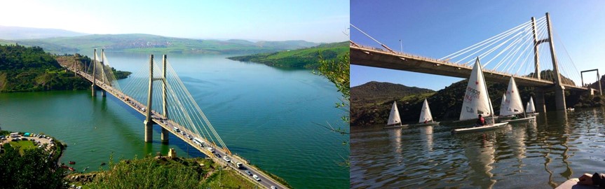
Natural side :
Fascinating sceneries of Beni Haroun dam and the bridge of Oued Edib.
Cultural side :
Old Mila, which was classified as a preserved sector on 11/29/2009, was established in the prehistoric era in the year of 256 Ad and it was one of the military basis.
– The archaeological site called Fardwa dates back to the Roman period. It is located in the north-east of Mashta, on the hill overlooking the road linking between Sidi Marouane and Mila. It has a pottery workshop, in addition to the presence of the remains of an old kiln, a pottery dump and a water bath “hammam”, with the possibility of the presence of an ancient cemetery.
– The archaeological site of Ain al-Kabirah is located on a high hill on the road linking the two municipalities Hamala and Sidi Maarouf, which is about 03.29 km away from Hamala municipality.
The reported site is registered in the general Census of Cultural Property List, and is mentioned in Archaeological Atlas of Algeria in the year 1911 by Stephane Ghazal under No. 72-71 Folio 08.
Historical side :
– the famous battle of Lefkalin, which claimed 41 martyrs on May 31, 1956, and more than 60 martyrs on August 14, 1956 in Old Mila.
– (Attacks in the north of Constantine) 08/20/1955
– In the battle of al-Wasaaf and the battle of al-Mashita on 09/26/1958 in the foothills of Jabal Masid Aisha, known as the concentration of the Mujahideen, and the battle of Qasras on 06/10/1955
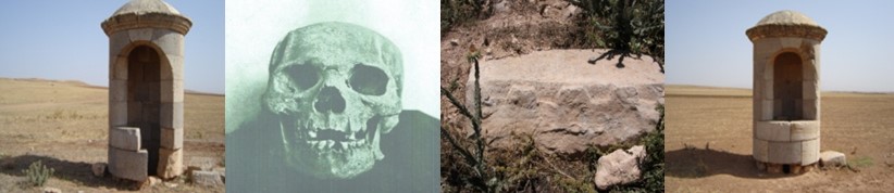
Torture Center in the municipality of Qararam Quqa.
Mashta Lamhasanieha, where the mass murder massacre took place on: 07/02/ 1956.
The site of the ambush of Ghar Selim, where 9 Mujahideen were martyred, and a reminder of the Balout Al-Zawish Cave at the foot of Mount Bounaja and the Buraq Al-Mujahidah area, which paid a heavy price in the lives of its sons during the revolution, exactly on 04/22/1956 with the martyrdom of 67 martyrs, an air attack by the enemy and the bombing of the village.
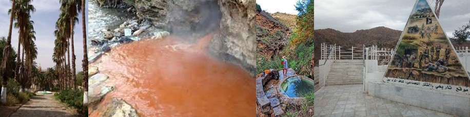
Natural side :
Fascinating sceneries in mechta hammam Ouled Achour.
Cultural and historical side :
. Torture center *Al-Burj *Zaghaya
. The torture center in Wadi Al-Najja.
. Al Rawashd Municipality:
A visit to the torture center * the fortified building tower * in the municipality of Al Rawashd.
The ruins of a hot mineral water facility dating back to the Roman period. The bath is located north of the city of Ferjiwa in the municipality of Bani Qishah, at a distance of more than 300 m. The bath is located on an area of 2 hectares and 67 meters. It is bounded on the north by Mount Boucharf, on the west and south by population centers, and on the east by the Red Kef. Only a few parts of the facility built by the Romans remained, represented by huge scattered stones and remnants of side walls.
. The Agha Palace, which was the residence of the Ottoman ruler, was classified as a national heritage on 02/10/1998 in the municipality of Ferjiwa
. The Red Prison, which was a center for the practice of torture and execution, and its name goes back to the color of the blood of the martyrs in the municipality of Farjiwa.
Historical side :
.Kaf al-Zawabiq, a historical site of mass murder in Mashtaat, Hammam Awlad Ashour, municipality of Al-Ayadi, Berbas, Mila.
Benn Al-Najari Trench, in which 320 martyrs were found, on March 16, 1986, in which the death sentence was being executed in the municipality of Zghaya
.Shebchoub farm in Sragneh, belonging to the municipality of Zaghaya, has a detention center and a training center.
The village of Umm al-Tabul, where a battle took place, during which the French enemy attacked, which left 13 martyrs and 06 wounded. The next day, the enemy forces marched heavily on the remaining residents of the village and killed 66 martyrs in the municipality of Al-Rawashid.
In the demonstrations of Umm al-Hajl for the citizens of the countryside of Virginia, where the citizens, men and women, went out in 4 marches in which they clashed with the enemy forces, which resulted in the fall of 15 martyrs and the battle of Kawarda on 12/15/1959, which resulted in the martyrdom of 9 Mujahideen
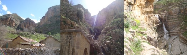
Natural side :
The Tameda region is famous for its natural water sources in which it makes
Waterfalls of fresh water formed at the bottom a small lake that attract many citizens to swim in.
A huge cave (darkness cave) in the mansupality Deraji Bouslah.
Cultural and historical side :
the archaeological site CASTULUM ZUGEL which dated back to the roman era. It contains several important archaeological sites such as a slaughtery place which is carved on the rock…
Historical side :
. Cave of Kaf Tamda, which is located in Mashtaa Ras al-Wad, south of Ahmed Rashidi, about 5 km away from it. It is a source of potable water. A massacre took place in the presence of the colonial butcher, Pego Lechar, and 27 martyrs were killed in less than half an hour.
. Edar Elhamra edahiriya and kaf Belaabadi where the conquest enemy made a huge compain against El mujahideen in the commune of Darraji Bouslah.
. Mashtaat al-Darabala, which is located south of the municipality of Ahmed Rashidi. Where the Mujahideen ambushed two military trucks of the enemy forces loaded with soldiers.
The touristic path Oum AlHanash Tiziman
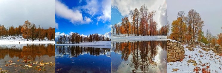
Natural side :
Fascinating sceneries for the lake of Om Lehnash in the commune of Tassadan Haddada which is located in a mountanous place called Tiziman. It rises 1250 meters above sea level, and this lake does not dry out all year long.
Tizi Man is a mountainous area rich with very beautiful landscapes, located west of the state of Mila. It is regionally affiliated to the municipality of Tasaddan Haddadah and is 20 km away from it. It is also 75 km away from the state capital Mila. It is bordered on the west by the municipality of Ain El-Sabt of the state of Setif and bordered on the north by the Iragan Mountains in the state of Jijel. It is also bordered on the east by the Satah forests and Jamila. It has a mountain peak more than 1500 meters above sea level and the thickness of the snow in it exceeds 1.5 meters. Tourists can climb the rugged summit of Timizqidah, which is more than 1600 meters above sea level. There are many sources and bodies of water in Tizi Man.
It has many birds, including woodpeckers, and has many wild animals such as the gray wolf, wild boar and hare.
Historical side :
Al-Safsaf Mashtaha, which is located in the southeast of the municipality of Zarza and is considered an important point of passage to the roundabout of Aras and Tesala in the field of supplies, mail and the liberation army regiments, which led the enemy forces to launch an attack on Al-Safsaf Mashtah from its nearby centers of Buraqah – Al Rawashd – Lante
Ain Aali is dispersed from the Zarza roundabout at the foot of Mount Bouafron, which is located in the northwest of the municipality of Minar Zarza. It is a high peak dense with cork and beech trees. Its geographical terrain is rugged and its paths are difficult. Its leaves fall in winter and snow also abounds due to its distinguished height above sea level. Where did several battles took place from 1957 to 1961.
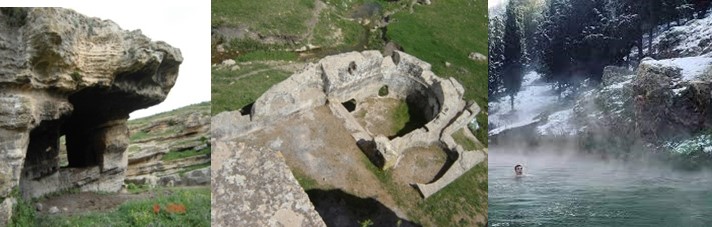
The Grouz Hammam area is characterized by a lake, which is the best destination for relaxation, swimming, and enjoying the hot water, in addition to practicing various outdoor sports activities. As it is surrounded by forests and charming landscapes.
The area is also distinguished by the archaeological site of Baalah, located in Mashtaat al-Baalah. The history of this archaeological site dates back to the ancient Roman period and occupies an area estimated at six hectares, in addition to the Bonibanos Hammam located next to the grouz Dam.
Historical side :
Oued Al Athmaniya munsipality :
. mashta Oulad El Kaseh is a building that was used by colonialism as a train station to transport iron from the mines of Mount Feltan to the Shaab El Rass station in Constantine
. Bouigor Valley, the location of the commando operation
. Ain Fowa, which is scattered in the slopes of Mount Shataba, about 3 km from the village of Jabal Aqaab, was the center of the revolution frequented by the Mujahideen
. Ain Al-Qadi is a place located north of the city of Wadi Al-Othmaniyah, about 02 km away where several violent clashes occurred between the demonstrators and the colonial forces.
Ain El Tine Municipality:
Kaf Al-Nesour: A place overlooking Awlad Boukhamis scattered and called Al-Shloukh Al-Hamr. Several battles took place between the Mujahideen and the colonizer.
Municipality of Sidi Khalifa:
The area of Awlad Zarara is scattered from the roundabout of Lafkaline, where several clashes have occurred.
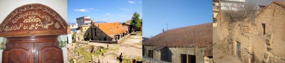
The mosque, which is located in the Archaeological Museum “Mila Al-Atika”, was built 13 centuries ago, specifically in the year 59 AH, corresponding to 678 AD, according to historical sources.
The story of its construction goes back to the Islamic conquests when the companion Abu Al-Muhajir Dinar conquered the city of Mila (ancient Milaf), which was under the Byzantine occupation (534-647 AD) and condemns its inhabitants to Christianity. According to historians
And it was mentioned in the Encyclopedia of “Islamic History – Conquest of North Africa” that Muawiyah bin Abi Sufyan dismissed Uqbah bin Nafi and took his place Abu Al-Muhajir Dinar (died in Algeria: 683 AD), who realized that “the population of North Africa is tough and it is necessary to deal with them with kindness.”
According to the encyclopedia, the policy of Abu al-Muhajir Dinar succeeded in attracting the Berbers to Islam, especially when he showed great tolerance with their leader Kusayla bin Lamzam, who later converted to Islam.
The “Sidi Ghanem” mosque, also called “Abu al-Muhajir Dinar”, is the second oldest mosque in the Maghreb after the Kairouan Mosque in Tunisia.
Bin Sheikh Al Hussein corner”zawiya”
A historical landmark dating back to the Ottoman era in Algeria (end of the eighteenth century AD). The house of Sheikh Al Hussein is located in Sidi Khalifa Al Olaya in the municipality of Sidi Khalifa, the state of Mila for every passerby.
The zawiya played a significant role, especially after the French occupation of Algeria in 1830. The zawiya provided material and moral support for the revolution
Municipality of Oued Segan:
– Al-Zawiya Al-Hamalawiya: The zawiya was founded by Sheikh Ali bin Khalifa Al-Hamalawy. The building consists of a shrine, which is a square room, in which the Sheikh of the zawiya was buried. Al-Zawiya Al-Hamalawiya is the largest historical zawiya in Algeria, and the Hamalawi family is also one of the ancient families.
Mushira Municipality:
Archaeological site Abar Aglad
The two wells are located in the Aglad area, about 15 km from the municipality of Al-Mashira, and 02 km southwest of the archaeological site of Putkhamatn. Which was called in the past Sparsanova and was mentioned by the traveler Atonan that it is located on the road linking Lambaz and Sitives and between Cirta and Diana, as it is the axis of the convergence of two main roads in the Old Testament The trace is two wells dating back to the Roman period, characterized by a beautiful architectural character that reflects the high duke of the Roman engineer, as well as the great interest that the Roman Empire gave to the irrigation system at that time. The two wells are cylindrical in shape, built with finely polished stones and end with a dome-shaped roof. It includes a rectangular window opening ending in an arched lintel.
Archaeological site Potchmatten:
A very important archaeological Roman city in ancient history, it occupies an area of about 20 hectares.
Awlad Khalouf Municipality:
The archaeological site of Ain Karma:
The history of the archaeological site of Ain Kerma dates back to the Roman period, and this is based on the urban features that were found at the site, namely an olive press, traces of water features built with polished stones, and two funerary inscriptions. The site is reached via the National Road No. 100, which links between Mila and Batna
Archaeological site of Mashta Al Arbi:
An archaeological station dating back to prehistoric times (the Neolithic era), Mashta Al-Arabi is located south of the city of Shalghoum al-Eid in the Wilaya of Mila, The station is about 05 km from the headquarters of the Shalghoum al-Eid municipality on the road linking the Shalghoum al-Eid municipality and the municipality of Awlad Khalouf southwest of the Jameh Lakhdar neighborhood. The southern basin of Wadi Al-Rimal, with an average height of about 800 m. This station is considered one of the most important prehistoric sites in Algeria, dating back to the Qafs civilization in North Africa